Physical Address
304 North Cardinal St.
Dorchester Center, MA 02124
Physical Address
304 North Cardinal St.
Dorchester Center, MA 02124
What 865 acres, sunk infrastructure, and a new zoning law could mean for Columbus — long after the first building opens.
What 865 Acres, Sunk Infrastructure, and a New Zoning Law Could Mean for Columbus — Long After the First Building Opens
This article is part of an ongoing series examining the financial and governance risks of Project Ruby. Previous reporting covered property tax volatility, the absence of minimum payment guarantees, and ratepayer cost exposure. This piece focuses on a separate but related risk: what the 865-acre site and the proposed zoning framework make possible beyond the first campus.
When Columbus officials talk about Project Ruby, the conversation is almost always about one data center campus: four buildings, 195 jobs, $5.18 billion in investment, 600 megawatts of power. That project gets described as if it has a beginning and an end.
It doesn’t. And understanding why is perhaps the most important thing Columbus residents can do before their City Council votes.
The land being developed for Project Ruby is 865 acres. The four-building campus would occupy roughly 130 of those acres — about 15% of the total site. The other 85%, approximately 735 acres of undeveloped land, remains in the hands of the same private developer who is building Project Ruby.
Now ask yourself: once the first campus is built, with its own power substation, water mains, sewer lines, and access roads already in place — what is to stop the developer from building a second data center on the adjacent land? A third? A fourth?
The honest answer, based on a careful reading of every public document produced about this project, is: nothing in the current plan prevents it. And once the infrastructure is in the ground, the economics make it nearly inevitable.
Choose Columbus — the city’s economic development arm — has pointed to the 15% figure as reassuring: most of the land won’t be cleared, most of the forest will remain. That framing is meant to address environmental concerns about tree loss and habitat destruction.
But the 15% figure contains a different kind of information depending on which question you ask. If you ask “how much land will be disturbed by Project Ruby?” the answer is 15%. If you ask “how much land on this parcel remains available for future data center development?” the answer is 85%.
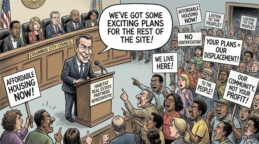
That 85% — roughly 735 acres — is not protected land. It is not under a conservation easement. It is not deed-restricted from industrial development. It is privately owned by Muscogee Property 1 LLC, a company created specifically for this project by Habitat Real Estate Partners. The developer has said publicly there are “exciting things planned” for the rest of the site, without specifying what those plans are.
Under the proposed Technology Overlay ordinance, any contiguous tract of 75 acres or more on an eligible parcel can apply for data center development through the standard rezoning process. The 865-acre site could theoretically be subdivided into multiple qualifying tracts. Each one could file its own application. Each one would go through a public hearing and council vote. And each one would arrive at that hearing with the most powerful argument in local development politics: the infrastructure is already here, and you already approved the first one.
How the math works
Project Ruby: 4 buildings on ~130 acres = 15% of the 865-acre site.
Remaining land: ~735 acres = enough for roughly 5 to 6 additional campuses at the same footprint, each qualifying under the proposed 75-acre minimum.
The current zoning framework has no mechanism to prevent this.
To understand why additional data centers become almost economically inevitable once the first one is built, you need to understand what “infrastructure” actually means in this context — and what it costs.
The Water and Sewer Lines. The developer is paying $30 million upfront to extend water and sewer lines from the city system to the remote Upatoi site. Once built, those lines get deeded to Columbus Water Works. The city then owns and operates a major industrial-grade utility corridor running directly to an 865-acre rural parcel. That infrastructure doesn’t disappear between buildings. It sits there, fully operational, waiting. The marginal cost of connecting a second data center to lines that already reach the property is a fraction of the cost of building those lines in the first place.
The Electrical Substation. Project Ruby will have its own dedicated electrical substation connecting directly to the high-voltage transmission system. Once a substation of that capacity exists, connecting additional buildings to it is an engineering problem, not an infrastructure problem. The committee’s own report noted that equipment lead times — sometimes 45 to 46 weeks for a single transformer — are the real bottleneck in data center construction. Once the core transmission infrastructure is in place, that bottleneck largely disappears for subsequent buildings.
The Roads. Access roads built to support construction and operation of the first campus — rated for heavy equipment, industrial trucks, and the constant traffic of a 24-hour facility — remain in place afterward. The proposed ordinance explicitly permits private roads within data center campuses, meaning the developer controls internal access without further public process.
The economic logic in plain language: Building the first data center on raw land costs X. Building the second one on land that already has power, water, sewer, and roads costs a fraction of X. The developer who absorbs the upfront infrastructure cost on the first project effectively pre-pays for the next several projects. That’s not an accident — it’s the business model.
Columbus is not the first community to face this question. The pattern of a single approved data center becoming a cluster — and then a campus — and then a defining feature of the local landscape — has played out in multiple places across the United States.
Loudoun County, Virginia — “Data Center Alley.” Loudoun County is home to the world’s largest concentration of data centers. It didn’t start that way. It started with individual project approvals, each justified on its own merits. The infrastructure followed. Then the next project cited the existing infrastructure as evidence of feasibility. Then the next one. Today, Ashburn, Virginia is so saturated that local governments spend years trying to impose limits they didn’t think to require upfront. Residents describe the landscape as fundamentally changed — and not in the way that was described to them when the first projects were approved.
Prince William County, Virginia. Prince William County went through the same sequence more recently and more visibly. One approved project, infrastructure built, subsequent applications citing existing infrastructure, rapid clustering. The county eventually passed a data center moratorium — after the fact, after the infrastructure was in the ground, trying to recover planning control it had already surrendered. A moratorium is not a solution. It is what happens when a community realizes too late that the time to set limits was before the first approval, not after.
The common thread: In every documented case of data center clustering, the pattern is the same: the first approval is the pivotal one, because it establishes the infrastructure and the precedent simultaneously. Every subsequent approval is easier, faster, and harder to deny. Columbus is at the decision point those communities faced.
The Unofficial Data Center Overlay Committee was hosted by the Columbus Chamber of Commerce and comprised 16 members drawn primarily from the local business and professional community. The committee included representatives from architecture firms, a major construction company, a civil engineering and land planning firm, a real estate developer, a credit union, a telecommunications company, a cybernetics firm, and a property management company. Several members work in industries where data center construction represents a direct business opportunity.
That is not a criticism of any individual on the committee. Every person listed appears to have participated in good faith. But professional background shapes instinct. People who spend their careers maximizing buildable area and minimizing regulatory friction bring those instincts to a policy discussion, even unconsciously.
What is striking is who was not in the room:
The residents who would live inside a 200-foot noise buffer had no one speaking specifically for their interests. The taxpayers who would be responsible for bond payments if revenue projections fall short had no advocate. The counties that border the site had no voice.
The proposed Technology Overlay ordinance — the zoning change that must pass before Project Ruby can be built — was reviewed by the same unofficial committee. Their 18-page report made 23 recommendations to strengthen the rules. The committee did genuine technical work in several areas, particularly on noise. But on the question of clustering and cumulative development, the framework has significant gaps.
No cap on the number of data centers. The proposed ordinance contains no limit on how many data center campuses can be built on a single ownership parcel over time. Each application is treated as an individual rezoning request, with no mechanism for considering the cumulative impact of multiple facilities on the same site.
The setback decision. The committee recommended a 200-foot buffer between data center buildings and neighboring residential properties, rejecting a 500-foot alternative. Their justification was geometric: on a small 50-acre site, a 500-foot setback consumes more than half the buildable land. But the Project Ruby site is not 50 acres. It is 865 acres. On a parcel of that size, a 500-foot perimeter setback would leave 650 to 700 acres still available for development. The committee’s small-site geometry simply doesn’t apply at this scale — and they never acknowledged that distinction.
The noise admission that makes the setback worse. The committee carefully explained the difference between standard noise measurements (dBA — what the human ear hears) and low-frequency vibration measurements (dBC — the chest-rumble hum that data centers actually produce). They explicitly concluded that walls and berms are largely ineffective against dBC noise. And then they recommended a 200-foot setback anyway — while acknowledging their dBC enforcement standard is “the newest piece of this and the one we are least sure about getting perfectly right on the first try.”
For residents who would live inside that 200-foot buffer during what the committee called a “learning period” of 12 to 24 months, that is a real and personal cost — not an abstract policy question.
The following table shows what is mathematically possible on the 865-acre Layfield Road parcel under the current proposed regulatory framework. These are illustrative scenarios, not predictions. But they represent outcomes the framework has no mechanism to prevent.
| Scenario | Approx. Acres Used | Data Centers | Potential MW Draw |
|---|---|---|---|
| Project Ruby as proposed | ~130 acres (15%) | 1 campus, 4 buildings | 600–900 MW |
| If 50% of site developed | ~430 acres | ~3 campuses | 1,800–2,700 MW |
| If 85% of site developed | ~735 acres | ~5–6 campuses | 3,000–5,400 MW |
Note: These are illustrative scenarios based on the Project Ruby site footprint. The current regulatory framework contains no mechanism to prevent any of them.
To put the upper end of that range in perspective: the entire state of Georgia uses roughly 17,000 to 18,000 megawatts at peak demand. A fully built-out data center cluster on this one site could eventually represent close to a third of that. That is not a prediction. It is the mathematical consequence of the site’s size and the absence of an aggregate cap — and it is a number that has not appeared anywhere in the public discussion about Project Ruby.
There is one more dimension to the clustering risk that has not been discussed publicly: the cumulative noise environment.
The proposed noise standards — even with the committee’s improvements — evaluate each data center building individually. A single building must meet the noise cap at the property line. But noise from multiple sources adds up. Two data center campuses operating simultaneously from different parts of the same large parcel produce a combined noise environment that is greater than either one alone. Three campuses produce more than two. The performance standard that each individual building must meet at its own property line does not measure — and does not limit — the total noise experienced by a neighbor surrounded on multiple sides by operating facilities.
The committee acknowledged they don’t yet know how to correctly enforce even single-building dBC standards. The framework for evaluating cumulative dBC exposure from a multi-campus data center cluster doesn’t exist yet anywhere in the country. Columbus would be building that problem into its zoning code before the tools to manage it have been developed.
None of this means Columbus should reject Project Ruby. A single, well-regulated data center campus with proper contractual protections could be a genuine economic benefit to the community. But the clustering risk compounds over time and becomes harder to address with each subsequent approval.
What responsible governance requires here is not a rejection of the first project but a master plan for the entire 865-acre parcel as a condition of approving it. That master plan should answer the following questions before the first shovel goes in the ground — while Columbus still has maximum leverage:
These questions have to be answered now — not after the infrastructure is built, not after the second application is filed, not after the precedent is set. Once the water mains are in the ground and the substation is operational, the city’s leverage to demand answers is substantially diminished.
Columbus is being asked to approve one data center campus on 15% of an 865-acre private parcel. The other 85% — with infrastructure already running to it — has no binding development limits attached to it.
Every community that has faced this decision and approved the first project without setting firm limits on the rest of the land has ended up with more than it bargained for. The time to ask “what about the other 85%?” is before the vote, not after.
Columbus residents who want to weigh in should contact their City Council representative before any vote on the Technology Overlay ordinance. The specific question to ask: what binding limits exist on development of the remaining land on this parcel, and when will those limits be established?
Sources: Columbus Chamber of Commerce Unofficial Data Center Overlay Committee Report (May 2026); Choose Columbus Project Ruby FAQ; CCG Technology Overlay District Draft Ordinance; documented data center clustering patterns in Loudoun County, VA and Prince William County, VA; Muscogee County property records. This article is intended for civic information purposes.